Marlowe's Childhood
Street Maps of Canterbury
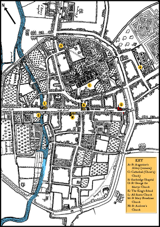
Some detailed street maps of the city of Canterbury from around Marlowe's time, showing streets and individual buildings.
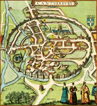
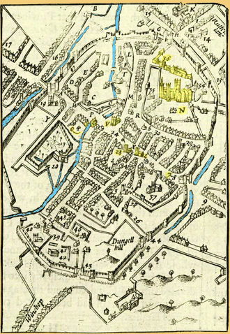
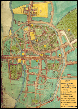
Landmark Key
The first letter label (e.g. A:) is that added to the Hoefnagel and Hand-Drawn maps. The final label in square brackets (e.g. [11]) is that on the original map by John Speed.
- A: St. Augustine's Abbey - what remained after it was demolished following the dissolution in 1538. [11]
- C: Canterbury Cathedral (Christ's Church) [N]
- E: Eastbridge Hospital [Q]
- G: The Church of St. George the Martyr [7]
- K: The King's School [36]
- L: All Saints Church [V]
- M: St. Mary Breadman Church [28]
- N: St. Andrew's Church [36]
Hoefnagel's Map of Canterbury (c.1568)
What is probably the earliest map of Canterbury appeared in the famous atlas Civitates Orbis Terrarum ('The Cities of the World') published in 1588 by Braun and Hogenberg.1 The map was engraved from an original drawing by Joris Hoefnagel (1542-1601) who is known to have visited London for a number of months in 1568. If that is when Hoefnagel drew this map of Canterbury, it would show the city as it was when Marlowe was aged just four. A similar map of Canterbury appeared in a book by William Smith2 dated October 1588, and is thought to be based on Hoefnagel's work. The map in Smith's book contains a key labelling a small number of city landmarks, including the church of "st. george".3
[View large image (1.9MB)]
Speed's Map of Canterbury (1611)
John Speed (1551/2 –1629) was an English cartographer and historian born in Cheshire. Having moved to London as a tailor, his interest in scholarship earned him enough patronage from the likes of Sir Fulke Greville to devote himself in his study and the production of maps. Queen Elizabeth was impressed enough with his work to grant him a room in the Custom House just upstream from the Tower of London in which to work.
Speed began work on an atlas of Britain around 1602, with his ambition being "to shew the situation of every Citie and Shire-town". The result, nearly a decade later, was The Theatre of the Empire of Great Britaine4 published in 1611 and 1612. A double page county map of "Kent with her Cities and Earles described and observed" included a detailed street map of the city of Canterbury as an inset, along with a key to some 72 labelled landmarks.
Most of the county maps included such town plans and those showing a "Scale of Pases" (paces) are believed to have been surveyed by Speed himself (some with the help of his son Stephen). The maps were printed from copper plates, with much of the engraving done by Jodocus Hondius in his Amsterdam workshop. Since the Canterbury map has a scale of paces, we may infer that the city was surveyed by Speed at some time between 1602 and 1611, and thus shows the city as it would have been known by Marlowe's parents who both died in 1605. The map is remarkably detailed, and the location of "S. George churc" is labelled [7] close to St. George's Gate, although no church building is shown there on the map.
[View large image (1.9MB)]
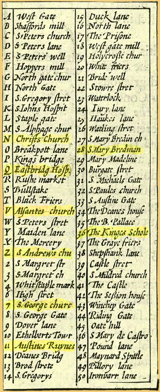
William Somner reproduced a version of Speed's map in his Antiquities of Canterbury published in 1640.5 Somner was born in Canterbury in 1598 and became registrar of the ecclesiastical courts of the diocese under Archbishop William Laud, but devoted his leisure to studying law and antiquities, as well as shooting with the long bow.
A Map of Canterbury (c.1640)
This map of Canterbury from around 1640 records the city some decades after Marlowe and his parents had died, but the city is unlikely to have changed significantly. It shows the streets and buildings to a level of carefully drawn detail that suggests there may be some accurate likenesses, at least for key buildings. The representation of the church of St. George the Martyr [G] where Marlowe was baptised, close to St. George's Gate, with its spire and crenelated tower, is recognisable from photographs of the church before it was bombed in WWII. The house where Marlowe may have grown up on the other side of the street can also be located. The careful detail showing the cathedral's architecture is impressive [C], and we also get some impression of the sights along the teenage Marlowe's daily journey to and from the King's School [K] just inside the North Gate.
[View large image (1.4MB)]
[View large image (1.7MB)]
Footnotes:
- Note 1: Vol IV (1588) of Civitates Orbis Terrarum (Cities of the World) by the German Georg Braun (1541-1622) and Flemish engraver Frans Hogenberg (1535-1590). Further information: The Canterbury Map (2019) by Lily Hawker-Yates [accessed 03 December 2021]. Back to Text
- Note 2: William Smith, The Particuler Description of England. With the Portratures of Certaine of the Cheiffest Citties & Townes. 1588. The plan of Canterbury is annotated with the date 10 October 1588. The map from Smith's book can be viewed at the British Library website [accessed 03 December 2021]. Back to Text
- Note 3: However, the label [10] on Smith's map for St George's is against a church shown on Burgate Street next to St Michael's Gate. The church of St George the Martyr is surely the one to the south of that. He also labels what is Greyfriars erroneously as St Mildred's [7]. Back to Text
- Note 4: John Speed, The Theatre of the Empire of Great Britaine: Presenting an Exact Geography of the Kingdomes of England, Scotland, Ireland, and the Iles Adjoyning; With the Shires, Hundreds, Cities & Shire-townes within ye Kingdome of England divided and described (John Sudbury & George Humble, London 1611). Back to Text
- Note 5: William Somner, The Antiquities of Canterbury or A Survey of that Ancient Citie, with the Suburbs, and Cathedrall etc (Richard Thrale, London 1640) Back to Text
- Note 6: A map of Canterbury c.1640 from the Canterbury Christ Church University Heritage A-Z [CCA/L Map 123]. Back to Text
- Note 7: The above map of Canterbury c.1640 traced and digitised by Sue Barnett of Canterbury Archaeological Trust - Canterbury Buildings website by Stephen Bax [accessed 21 July 2021]. Back to Text